
Ranger Series - miniRanger
PHOENIX LiDAR SYSTEMS

Multi-Platform LiDAR Solutions
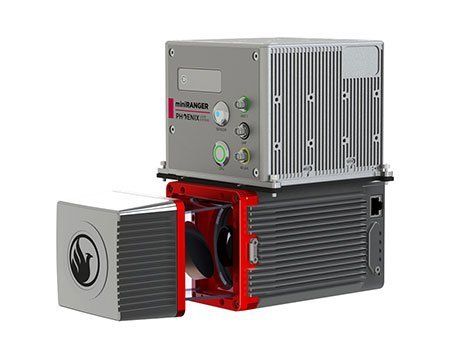
mini Ranger
Designed for UAVs, a compact, high definition and range LiDAR mapping system.
The miniRanger is a weight-opitmized version of our full-sized, high-density Ranger mapping system. This extremely compact system is the first of its kind to enable operating flight altitudes up to 100m AGL and delivers high-density data with up to five echoes, making it an ideal option for demanding UAS/UAVs applications.
Features
- Survey-grade (cm-level) accuracy with 250m+ laser range and outstanding intensity calibration
- IMU and dual-GPS upgrade options for increased accuracy
- Modular upgrade options: Dual LiDAR Sensors, DSLR, GeniCam, GigEVision, thermal, multispectral, hyperspectral and custom sensors
- Fully autonomous, can be mounted on any drone, car, boat and/or even backpacks
- Designed by surveyors for surveyors
Specs
- Absolute Accuracy:
25 / 35mm RMSE @ 100m Range - PP Altitude Heading RMS Error:
0.009 / 0.019° IMU options - Weight:
3.5 kg / 7.7 lb (FOG IMU)
2.9 kg / 6.4 lb (STIM IMU) - Overall Dimensions:
30 L x 9.9 W x 8.5 H (cm) - Laser Range:
250m @ 60% - Scan Rate:
100k shots/s, up to 5 returns